Satellite positioning accuracy of forest machines moves to a new level
The introduction of real-time satellite positioning correction (RTK correction) has raised the positioning accuracy of forest machines to a new level. Positioning, which previously worked with an accuracy of one metre, now reaches the decimetre range, which significantly improves the accuracy and utilisation of the machine’s location data.

-
That’s a remarkable amount of work hours for a single machine, the Norcar 600 owned by Erkki Rinne is taken well care of, it even has the original Diesel engine.
-
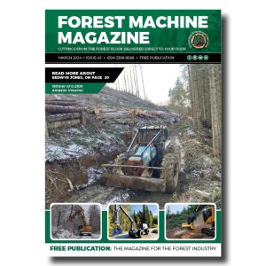
Kieran Anders is a forestry contractor working in the lake district. His work involves hand cutting and extracting timber using a skidder and tractor-trailer forwarder.
-
It is not possible to eliminate chain shot, but there are simple steps that can be taken to reduce the risk.
-
Arwel takes great pride in the fact that the mill has no waste whatsoever, “the peelings are used for children’s playgrounds, gardens and for farm animals in barns in the winter and the sawdust has multiple uses in gardens and farms as well.
-
Timber hauliers need to encourage young blood in, and also look after the hauliers we have, we need make the sector a safe and positive place to work.
FIND US ON
Related Posts
Thanks to RTK correction, a more accurate location of the harvester and further the harvester head makes it possible, for example, to know the locations of felled trees.
The main goal of the study was to find out how accurately a precisely located harvester can determine the location of a felled tree. In addition, it was investigated how the location information of the harvester head can be used to identify trees on the driving track. This information can be used to estimate the starting growing stock of a stand, as the trees felled from the drift tracks are thought to reflect the growing stock of the stand to be harvested before felling.
Based on the results, the average difference in location between the location of the tree determined by the harvester and the location measured in the terrain was 0.54 metres. Identifying the driving track trees through the location information of the harvester head proved to be a functional method, although some differences were observed in the accuracy of the starting tree identifiers derived from the driving track stand. The accuracy of the method is greater the less variation there is in the trees, terrain, driving track network and pattern shape.

A positioning accuracy of half a metre already provides a good basis for supporting the driver’s work, for example, in examining the location of boundary lines. The improved accuracy also opens up new opportunities for collecting and utilising forest spatial data in various calculation and planning applications.
Metsäteho press release
Contact forestmachinemagazine@mail.com to get your products and services seen on the world’s largest professional forestry online news network.
#homeoflogging #writtenbyloggersforloggers #loggingallovertheworld
Written by loggers for loggers and dedicated solely to the equipment used in forestry operations.